Location Matters! LandPKS Can Provide Point-Scale Soil Information

The Land Potential-Knowledge System (LandPKS; landpotential.org), a joint USAID-USDA program, was created to help put valuable information about the land, including climate, soils, and vegetation, in the hands of land managers across the world. It does this through the use of the LandPKS Mobile app, which is free to download and use for both Android and iPhone. Importantly, LandPKS is a way to both input and access data that is point-based and geo-referenced. The LandInfo module is one component of the LandPKS app and allows the user to obtain information about the soil directly beneath their feet. The LandInfo module walks a user through digging a hole and hand-texturing the soil to determine the soil texture and available water holding capacity or AWC. Future versions of LandInfo will also include infiltration rates, organic matter, soil color, and have algorithms that match the user-input data about soil texture with global soil maps to provide the user with the specific name of their soil.

The point-based model used by LandPKS is incredibly powerful because in many parts of the world the soil varies significantly from place to place and these changes in soil types can have dramatic impacts for farmers and others aiming to utilize that land. One excellent example is from the village of Nyamihuu, located near Iringa, Tanzania (photo below).

LandPKS plots dug in three sites in Nyamihuu, Tanzania (Lower Field, Upper Field, and Forest), and the LandPKS results for Available Water Holding Capacity for each location.

With local farmers, the LandPKS team dug three LandInfo Plots within a short distance from each other on a slightly sloping landscape. The differences in soil texture and AWC were quite drastic, with the Lower Field having almost double the AWC of the Upper Field. This has serious implications for farmers because the Lower Field will be generally more productive due to the greater ability to hold water in the soil for crops to utilize. Further, the Forest plot had by far the lowest AWC, which is important because it suggests that clearing the forest for cultivation may not be worth the effort and environmental impact.

The lesson here is that location matters! Soil can vary from one farm to the next, and LandPKS can empower farmers, agricultural extension agents, and others to gain access to site-specific soil information. Knowing your soil texture and AWC can influence what decisions are made. First, it can help a land manager decide if they want to farm a piece of land or not. As the example of the Forest plot above shows, some land is not suitable for agriculture, and LandPKS can help provide knowledge to show this. Second, soil texture and AWC may influence decisions about crop selection or crop varieties. Planting crops that are suitable for their specific soil will help farmers increase production and farm more sustainably. For example, the farmer on the Upper Field may want to plant more drought resistant crops or practice water conservation measures in order to make up for the lower AWC of their farm. Location matters, and LandPKS is one tool that can provide point-based, geo-referenced data to those who need it to make more sustainable land management decisions. For more information about LandPKS please visit our website at landpotential.org or e-mail us at contact@landpotential.org.

USAID joins first ASEAN Land Governance Summit in Manila

Originally appeared in USAID SURGE Project’s Cities Development Initiative Newsletter.

USAID’s SURGE Project joined the first ASEAN Land Governance Summit in Manila on December 4 to 5, 2017. The summit, with the theme “Aligning Competencies toward Sustainable Good Land Governance”, gathered more than 400 public and private sector representatives from the ASEAN member countries, as well as dialogue partners from Australia, China, and Taiwan, with the special participation of the United Kingdom and the United States of America.

SURGE Project Chief of Party Bradley Baxter gave a presentation on asset management for local government units, and described how cities can improve revenue generation and service delivery through asset management. The SURGE Project previously developed an Asset Management Manual contextualized to the setting of Philippine urban cities, and during the summit, the governments of China, Malaysia, the Philippines, Singapore and Thailand requested for a copy of the manual.

Plenaries were organized in multiple inter-related themes of Geodetic Network Development and Cadastre, Land Administration, Land Surveys for Land Development and Local Government Geomatics. These provided the opportunity to share local innovations and practical solutions in land governance. The summit was held in conjunction with the 65th Council Meeting of the ASEAN Federation of Land Surveying and Geomatics, hosted by the Geodetic Engineers Development Foundation.

Click below to read the full newsletter.

Cities Development Initiative Newsletter
News update from USAID CDI partner cities

Enter

keywords

Ownership, Simplified

How farmers in collective land ownership agreements are seeing their land rights disentangled, twenty years later.

MORE THAN HALFWAY THROUGH THE MANDATE OF THE VICTIMS’ LAW, THE LAND RESTITUTION UNIT CONTINUES TO PRODUCE THE NECESSARY TOOLS TO IMPROVE THE PROCESS OF RESTITUTION. RICARDO SABOGAL, DIRECTOR OF THE LAND RESTITUTION UNIT, SPEAKS ABOUT USAID’S SUPPORT IN STRENGTHENING RULING COMPLIANCE AND THE CREATION OF AN AMBITIOUS INFORMATION SYSTEM LAUNCHED IN 2017 WITH USAID SUPPORT.

A BLESSING IN DISGUISE

In 1997, the Colombian government gave Laurencio Avila and 19 other farmers a collective land grant to be divided amongst themselves and their families. The land had not been farmed, though some used it for grazing. The nearest main road was still not paved, and there was no access to basic services like water and electricity. Over ten kilometers away from the municipality center of Fuentedeoro, the 165 hectares of land, known as La Española, felt very isolated.

“We established a main camp up on that hill and started preparing the soil,” explains Avila. Under the deal, each farmer received eight hectares of land and agreed the farmers association that would eventually become a cooperative, meant to increase their ability to negotiate with buyers.

The group, which calls itself Asoproes, got off to a rocky start. With no previous experience in running a business this large, members made accusations against one another, distrust grew. The land reform project slowly fell apart. To make matters worse, the association’s president was disappeared by paramilitaries. Every year, the association had issues with members who could not pay their share of land taxes on time. Soon, the group began looking for ways to turn their communal property into individual parcels; a land title for each family.

“It was embarrassing, because we were these supposedly lucky beneficiaries, and everybody would ask us why we were still poor,” says Avila.

The group sent Julio Cesar Serrano, who was then emerging as the association’s new leader, to Bogotá to meet with public servants from former land administration entity, INCORA, to figure out what they needed to do to get individual property titles. In addition to giving the farmers more power over their futures, property titles are critical for opening doors to financing for rural citizens. Without individual titles, the farmers were losing bank credits that could help them buy inputs or hire labor at the right time. More than 15 years went by with little progress.

“Just two weeks ago, I went to the bank to ask for a loan, but without a cosigner, I don’t qualify. If I had a land title, the evolution of our business could be different,” explains Avila. “Eight million pesos I would have used to buy inputs and hire manual labor. Every year it’s the same, with no capital, the risk of loss is greater.”


USAID Land Champion: Daler Asrorov

Tell us about yourself.

I am an Economic Growth Project Management Specialist in USAID/Central Asia’s Tajikistan Country Office. I provide program management within our economic portfolio in different sectors, including: land policy, regional energy, and regional trans-boundary water resource management.

I manage the Feed the Future Land Market Development Activity (LMDA), a 4-year, $10 million program that aims to promote the creation of a land market where farmers are able to buy, sell, and lease their agricultural land to those interested in acquiring access to new land. The activity is also promoting a simple and transparent land registration process with equal access and rights for men and women. I work closely with the implementing partner, high level government authorities, other donors, NGOs, and the business community to ensure the success of this program.

Why is land tenure/property rights important to Tajikistan? Why is it important to USAID?

USAID supports the Government of Tajikistan’s agrarian reform efforts to increase agricultural productivity through the Feed the Future Initiative, which works to: strengthen land rights, expand the availability of quality agricultural inputs, improve crop diversification, and facilitate market development. The Feed the Future LMDA program supports these objectives and continues USAID’s support for land reform and farm restructuring in Tajikistan, which began in 2004. To date, land reform and farm restructuring have significantly increased investment in the Tajik agricultural sector. Evidence shows this work has increased crop diversity and contributed substantially to increasing dietary diversity and incomes in rural Tajikistan, directly addressing the goals of Feed the Future in Tajikistan.

Through LMDA, USAID assists the Government of Tajikistan to achieve the next stage of the reform process, which is to establish a land market system that can ensure the orderly transfer of land rights in Tajikistan. The lack of a functioning land market puts all previous gains at risk. Efficient agricultural producers cannot expand their operations without the right to buy and sell agricultural land. Farmers who may want to start other enterprises or relocate cannot effectively liquidate their equity in land. They may not use land for collateral to obtain loans to improve agricultural profitability. Without the right to buy, sell, and mortgage a plot of land, farmers lack the means and incentive to invest funds to improve and diversify production.

What are some of the biggest challenges you see in addressing land tenure/property rights issues? And how are we tackling these challenges?

The cultural roles of women in Tajikistan vary widely by region but it is generally difficult for women to meet with officials to gather information about agricultural opportunities. At the same time, women carry out most of the agricultural labor in the country, but few women are farm heads. As the manager for USAID’s previous Land Reform and Farm Restructuring Project (2013 – 2016), I worked to ensure that land reform activities were gender balanced and our implementing partner considered Tajikistan’s social norms and behavior for various project activities and approaches. As the manager for LMDA, I continue to work to ensure that the implementing partner integrates the different roles women and men play in communities and societies, as well as the different levels of power they hold, their differing needs, constraints, opportunities, and the impact of these differences on their lives.

What are the some successes you have achieved (or USAID has achieved) in the land sector?

At Tajikistan’s independence in 1991, large-scale collective Soviet farms (1,000-2,000 hectares of irrigated land with around 2,000 workers) managed all of Tajikistan’s land. Land reform and farm restructuring began in the early 1990s with the reorganization of 562 collective farms into approximately 5,000 independent, commercial dehkan (peasant) farms that were each between 50-100 hectares. USAID has supported the Government of Tajikistan’s efforts since 2004 through a series of programs which focused on: restructuring and breaking up these large commercial dehkan farms into individual and family dehkan farms; registering land use rights and issuing land use rights certificates of people’s land plots; and granting “freedom to farm,” e.g. allowing farmers to choose what crops to grow.

These actions produced tangible results. Land reform and farm restructuring has reorganized most of the 5,000 commercial dehkan farms into a current total of 140,000 family and individual dehkan farms. Individual and family dehkan farms now cover 81 percent of Tajikistan’s irrigated agricultural land (500,000 hectares) and 100,000 hectares of orchards. Within the Feed the Future Zone of Influence, women own land use rights on 42.6 percent of land, which is double the rate of ownership outside of the zone.

Additionally, the Freedom to Farm policy has significantly reduced government influence over what farmers grow. A World Bank survey on the impact of land registration found that the percentage of farmers growing cotton dropped from 51 percent in 2007 to only 12 percent in 2015, with a corresponding increase in the percentage growing high value vegetable and orchard crops (41 percent increase in farmers growing onions, 42 percent increase for potatoes, and 36 percent increase in orchards).

During the implementation of USAID’s previous Land Reform and Farm Restructuring Program, the updated Land Code amendments were adopted and, in concert with the Inter-Ministerial Working Group, the Government and Parliament successfully approved a number of critical regulations, including the adoption of a completely new Law on Dehkan (Peasant) Farms that was approved in March 2016. This new law should provide an increased sense of security to citizens. This security is critical if we expect people to sustainably care for their land and make key investments to increase the productivity of their land for agriculture or other purposes.

Final thoughts?

Drafting and adopting the implementing regulations for land reform in Tajikistan is only the beginning. More effort is needed to create an active and transparent land use rights market. USAID in Tajikistan continuously works with government counterparts to ensure understanding and buy-in in regards to strengthening land rights and reforming land policy in the country. USAID encourages the government to develop additional institutions, like registration, valuation, and mortgages to enable the development of a functioning land market. This is an important step to increase food security in Tajikistan.

Public Land On Display

How strengthening the capacity of local officials to formalize land opens doors to investment and rural development.

Originally appeared on Exposure.

DISCOVERY PARK

The small town of Puerto Santander anxiously awaited the installation of its first sewage system when city workers unearthed quite the surprise. Calcified human bones, ceramic shards, and urns turned up in a layer of sediment less than a meter below the surface. It turns out the town, which borders the Ariari River in Meta, sits on land that was once a burial ground for the ancient Guayupe people.

Following the discovery, residents began digging up their yards, yielding fascinating pieces like bowls, tools, and funeral urns with ornate designs depicting bats with human characteristics. At first, they stored all these pieces in a room behind the police station. Eventually, they converted this room into a makeshift museum. But due to humidity and a lack of protection, some of the pieces began falling apart.

Oscar Ortiz, who lives in the area, began to worry about losing what up until that point was arguably the most important archeological discovery in the region of Meta.

In 2001, the Fuentedeoro municipal government spent its own money to convert the police stand into a small museum. However, the land on which the police station stands had never been formalized, and this lack of a registered property title made it difficult for the municipality to mobilize funds from regional and national government agencies to invest in the museum.


Online Training for Using the LandPKS App – Available Now!

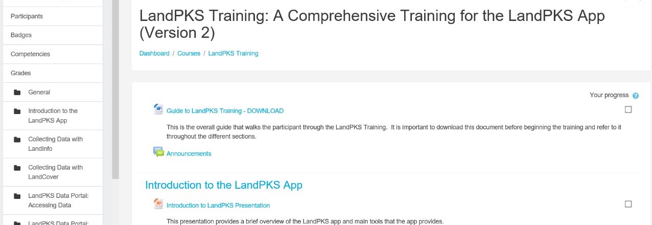
The Land Potential-Knowledge System (LandPKS; landpotential.org), a joint USAID-USDA program, was created to help put valuable information about the land, including climate, soils, and vegetation, in the hands of land managers across the world. LandPKS does this through the use of their free, open-source LandPKS mobile app that allows users to enter data about their land and receive valuable results right on the phone. Sound like a useful tool for you and your work? Want to learn more about using the LandPKS app as well as accessing and interpreting your results on the phone and on the LandPKS Data Portal (portal.landpotential.org)? Now it is as easy as accessing our new online LandPKS training at http://learn.landpotential.org/. You can create an account to track your progress or use the training as a guest. If you have any trouble accessing the training, please contact us as contact@landpotential.org.

We have created this online LandPKS training so that it can be completed by anyone, anywhere, at any time. The LandPKS team gets requests to conduct LandPKS trainings all over the world, and unfortunately we are unable to fulfill most these requests due to time and budgetary constraints. With this online training, now LandPKS users anywhere can complete the online training without waiting for an in-person training or consultation. This makes it easier than ever to learn how to effectively use LandPKS for making more sustainable land use decisions. Upon completion of this training, participants should be able to:

  • Use the app independently when it runs smoothly,
  • Access the Data Portal, and
  • Analyze and interpret the output in specific application contexts.

The online training can be completed in its entirely, or a participant can choose which sections they wish to complete. There are currently seven sections including:

  • Introduction to the LandPKS App
  • Collecting Data with LandInfo
  • Collecting Data with LandCover
  • LandPKS Data Portal: Accessing Data
  • LandPKS Data Portal: Analyzing and Interpreting Data
  • LandPKS Phone Output: Accessing, Analyzing, and Interpreting Data
  • Training Conclusion

Our online training was adapted from the One-Day LandPKS Training that was developed in Nairobi, Kenya by Amy Quandt (LandPKS Global Coordinator), Michaela Buenemann (Associate Professor of Geography, New Mexico State University), and Lillian Ndugu at the Regional Centre for Mapping of Resources for Development (RCMRD). The full One-Day Training Materials are available upon request and meant to guide an instructor in teaching a full in-person training on LandPKS. If you would like access to this full training, please e-mail us at contact@landpotential.org.

Cashew Trees Abuzz in The Diamond Mining Areas of Côte d’Ivoire

Beekeeping is helping cashew farmers in diamond mining communities increase yields and diversify their livelihoods away from dependence on diamonds.

Two years ago when the Property Rights and Artisanal Diamond Development (PRADD II) project in Côte d’Ivoire began a beekeeping program in cashew plantations, villagers were skeptical.

“You said you want to help us, and now you send us insects that go piquer-piquer (bite-bite)?” said Kone Inza, president of a youth group in the village of Bobi.

Beekeepers in Tortiya curing hives they built with PRADD II technical assistance. Photo Credit: Terah DeJong/Tetra Tech

Now with over 1,000 kilos of honey produced by two dozen beekeepers who have placed hives under the shade of cashew trees, communities in the diamond mining areas of Séguéla and Tortiya are abuzz with excitement. The honey not only sold out within days of harvest, but the bees are also helping increase cashew yields up to 50% on some farms.

The PRADD II Project supports governments to implement mining best practices in Côte d’Ivoire and the Central African Republic, and promotes good governance of the mining sector at the international level. As a non-renewable resource, when diamonds are mined out, it often leaves a devastated landscape, full of deep and dangerous pits. In Côte d’Ivoire, however, diamond miners are investing their profits to rehabilitate these unusable lands by filling in the pits and planting cashew trees, responding to high international demand and prices for cashews.

PRADD II supports income diversification, such as beekeeping in cashew orchards, in diamond mining communities because cashew production helps mitigate against declining revenues from diamond mining. As a result of participatory action research carried out by the PRADD II team, project staff observed that bees are attracted to the juicy cashew apples and wondered whether bee hives could be placed under the trees. PRADD II learned from the USAID funded African Cashew Alliance that in nearby countries such as Benin, beekeeping can significantly increase the yields of cashew trees, sometimes up to 100%, while also generating highly profitable honey. Thus was born this initiative.

“What’s nice is that the bees do most of the work,” said Fofana Abou, head of the newly created beekeepers association in Forona village. “And it’s helping our cashew trees as well.”

Indeed, after reading how beekeeping was used in Benin, Ghana, and Togo to increase pollination and improve cashew yields, PRADD II contacted the national cashew board and the GIZ-led ComCashew project, who agreed to provide valuable technical assistance for a pilot and co-fund an impact study.

The results after the first year of testing were presented during a conference in September attended by African cashew research scientists. The study found that raw cashew nut yields in the PRADD II intervention plots were on average 15% higher than control plots—not as high as in neighboring countries, but still promising. A follow-on study to explore how to further increase yields has been planned. However in the meantime, PRADD II has trained over 50 new beekeepers and is offering incentives to further scale up the pilot, including providing one hive for every hive made or purchased by a beekeeper.

PRADD II is closely monitoring the cashew supply chain: after diamonds, cashews are the second most important livelihood in the project’s intervention areas. Satellite imagery analysis shows that cashew trees, introduced as an anti-desertification strategy, covered no land in the late 1980’s but today cover nearly 3,500 hectares in the Séguéla area. Though cashew nut prices fluctuate on the international market, cashew trees are hearty and drought resistant, providing a more sustainable livelihood for the people that depend on land that has been historically degraded by diamond production.

Cashew Tree apples with protruding cashew nuts. Beekeeping increased production of cashew nuts by 15% in the Séguéla and Tortiya diamond mining communities. Photo Credit: Terah DeJong/Tetra Tech

This growth in cashews has led Côte d’Ivoire becoming the world’s largest cashew exporter. Unfortunately however, the country’s cashew nut yields are among the lowest in the world. By introducing bee hives into cashew tree orchards, PRADD II hopes to not only contribute to significant increases in the trees’ yields, but also generate supplemental income for the beekeepers.

The boom in cashew tree production is also changing land tenure dynamics as diamond mining areas are converted to cashew tree orchards. Since land uses are rapidly changing, PRADD II is facilitating community land-use planning as well as working with cooperatives to map out farm ownership to secure ownership and prevent conflict. PRADD II has also helped draw attention to the risks associated with the cashew boom through its outreach to national policymakers. The project produced studies showing parallels to the cacao belt, where land tenure conflicts and vulnerabilities stemming from commodity price fluctuations contributed to the country’s 2002-2012 violent political crisis. Productive farms, secure land tenure, and diversified livelihoods are key ways to avoid risks that may lead to conflict.

With PRADD II’s support to expand beekeeping, local farmers are better prepared to help mitigate those risks.

New Technology is Shaking Up The Diamond Mining Industry in Côte d’Ivoire

In the diamond mining regions of Côte d’Ivoire, the introduction of new technology is increasing the volume of stones that enter the legal chain of custody, leading to increased earnings and more sustainable livelihoods for miners.

During a recent test of the first ever diamond washplant for artisanal miners in Côte d’Ivoire, Bobochi, the president of the local miner’s cooperative in Oussougoula village, recounted how the “jiggy-boy” revolution in the 1950s changed his life.

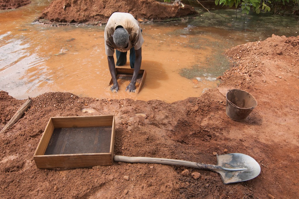
At the time, some foreign-owned semi-industrial companies were closing operations in the diamond mining area of Séguéla, and artisanal miners moved in, hoping to find diamonds that may have been left behind. Few knew the proper technique for swishing around the gravel in a way that removes silt and sand, while concentrating the denser diamonds. After learning this swishing technique from a Sierra Leonian migrant worker, young Bobochi would roam the bush shouting “jiggy-boy!” to advertise his swishing services.

The saved time and money from the hand auger can help diamond mining cooperatives become financially independent. Photo Credit: Terah DeJong/Tetra Tech

Bobochi has been an artisanal miner ever since, thanks to the technology knowledge transfer from the Sierra Leonian. Since then, the round jig he used gave way to a rectangular one. Another simple but also revolutionary change included water pumps which made it possible to mine year-round.

Now the Property Rights and Artisanal Diamond Development (PRADD II) project enters into the picture. The USAID and EU-funded PRADD II project supports governments to implement mining best practices in Côte d’Ivoire and the Central African Republic, and promotes good governance of the mining sector at the international level through the Kimberley Process, the international mechanism that prevents rough diamonds from fueling conflict. After years of consultation with artisanal miners like Bobochi, PRADD II introduced two new game-changing technologies: a hand auger and a semi-mechanized portable washplant.

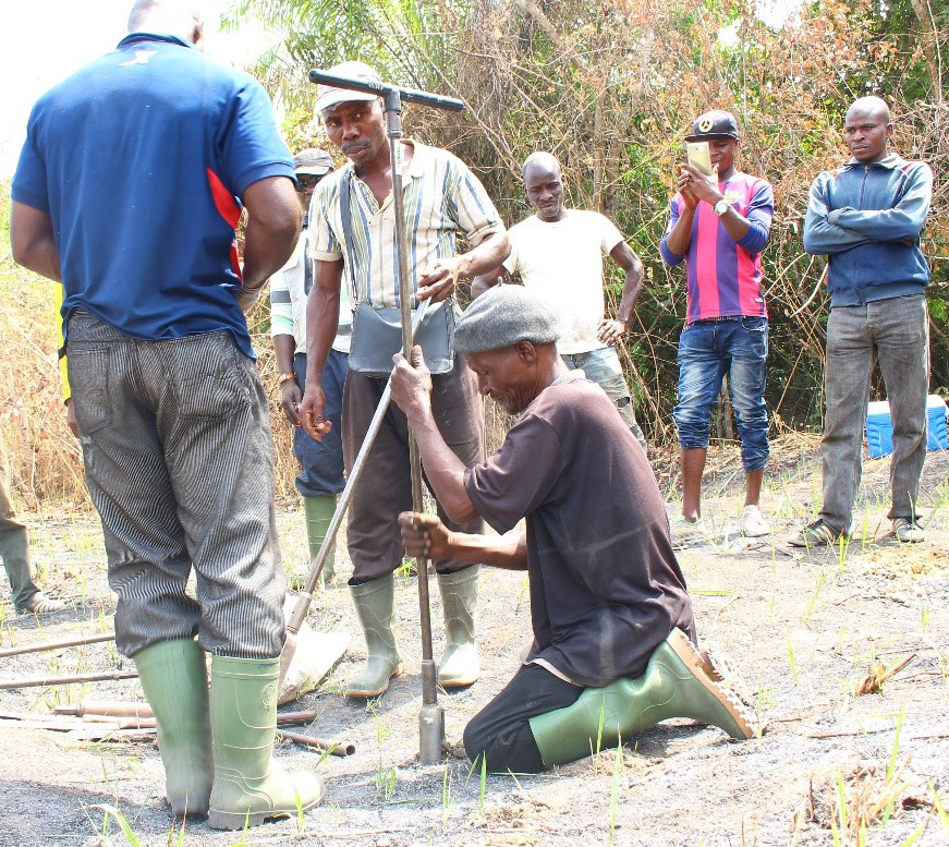
The hand auger helps identify the location of relatively shallow underground diamond deposits located in and around the meandering rivers of Séguéla. The auger is a game-changer for miners who use it to locate diamond gravel deposits without spending weeks in fruitless digging of deep test pits. By twisting the auger into the ground, core soil samples are drawn. A certain type of gravel indicates the probable presence of diamonds. When this diamondiferous layer is discovered, miners like Bobochi go to work to excavate large pits to the gravel level, draw it out, and then wash it to remove the diamonds. The hand auger was introduced by the U.S. Geological Survey in 2015 as part of research collaboration between PRADD II and SODEMI, a company partially owned by the government of Côte d’Ivoire.

Meanwhile PRADD II also imported a customized washplant built in Ireland. As the picture here shows, this is a portable machine that simultaneously sifts and washes diamondiferous gravel. This saves miners an enormous amount of time normally spent sifting tons of gravel by hand. In addition, the beauty of the unit is that it uses the same motors found in locally available water pumps. The designer also shared the washplant specs with local blacksmiths, allowing the washplant to be fabricated and fixed locally. Local mechanics worked with a pioneering young entrepreneur – the recipient of a PRADD II sponsored business plan competition – to resolve several technical challenges. The foundation for the scaling-up of the washplant technology is now in place.

The washplant is creating both apprehension and excitement. Some old hands like Bobochi are skeptical as they remember when foreign diamond companies used machines decades ago that apparently hid diamonds, or didn’t work well enough, leaving missed diamonds in the gravel for artisanal miners like him to pick through. Diamonds financiers are very enthusiastic, however, as the machine will reduce the chances of theft and loss, both problems in manual washing. For the same reason, Ivorian authorities hope this will increase the volume of diamonds that enter the formal chain of custody, and workers are looking forward to less time standing in dirty water under the hot sun.

Traditional washing and sorting requires standing for hours in muddy water. Photo Credit: Terah DeJong/Tetra Tech

For the diamond mining worker cooperatives of Séguéla, the saved time—the machine can do a day’s work in 15 minutes—translates into saved money. For the first time, cooperatives are thinking of operating sites themselves without financing from outside buyers, as a result of this new equipment and all of the potential hours of labor saved. Helping overcome this key obstacle of access to finance is another major benefit of this new equipment.

As with all game-changing innovations, some will benefit more than others, and PRADD II is monitoring the test phase of the washplant. The communities are as well, since just as the round jig created new opportunities for “jiggy-boys”, the diamond sorting machine could do the same for a new generation. For miners like Bobochi, this latest technological revolution will save both time and money, meaning local miners can invest profits from diamond mining in other potentially viable opportunities, including profitable cashew tree production, improved housing, and education for their families.

There is No Sense in Doing Such a Complex Job to Lose it All in the End

Q&A with Ricardo Sabogal, Director of the Colombia’s Land Restitution Unit

Originally appeared on Exposure.

MORE THAN HALFWAY THROUGH THE MANDATE OF THE VICTIMS’ LAW, THE LAND RESTITUTION UNIT CONTINUES TO PRODUCE THE NECESSARY TOOLS TO IMPROVE THE PROCESS OF RESTITUTION. RICARDO SABOGAL, DIRECTOR OF THE LAND RESTITUTION UNIT, SPEAKS ABOUT USAID’S SUPPORT IN STRENGTHENING RULING COMPLIANCE AND THE CREATION OF AN AMBITIOUS INFORMATION SYSTEM LAUNCHED IN 2017 WITH USAID SUPPORT.

Q: Where is the Land Restitution Unit currently in terms of its mission to execute its land restitution policy, and how are achievements being measures?

A: After six years, our balance sheet is quite positive. We are present across the country and have received more than 100,000 claims. Of these, the LRU is working on 60%. Every day, judges issue rulings. To date, judges have ruled on more than 200,000 hectares, and there are another 600,000 hectares in the cases, on which they are deciding every day. And most importantly, families are returning to their land and are not leaving due to violence. They’re working the land and many of the families are exporting what they are harvesting, all thanks to the land restitution policy.

Q: What have been the biggest problems and challenges in the implementation of the land restitution policy in its different stages (administrative, judicial and post-ruling)?

A: At first, the big challenge was the fact that we were entering the world of transitional justice—we did not know how to operate a public policy with these types of characteristics, and there was no technical bureaucratic mechanism in place. Additionally, the country has a huge problem with land administration, an outdated cadaster and property registry, or at least the one it has does not correspond to the cadaster. Another issue was security in many areas of the country. When we started off it was not possible to intervene due to violence. With the Peace Accords, new difficulties arise in many areas, such as the issue of landmines. Another challenge is ensuring that all institutions reach rural areas. The LRU might be there, but sometimes others are not. The agencies in charge of rural housing, the Agency for Rural Development, those responsible for roads, or health, and education. They all need to be present.

Q: How has USAID supported the LRU in the implementation of the restitution policy at the different stages of the process?

A: USAID supported the creation of the strategic plan, helping define where to go. When we began with the land restitution policy, there was no reliable estimate of the number of cases. Thanks to USAID’s support, we studied the data and made an estimate that was closer to reality. We sent the estimate to our honorable Constitutional Court, to say: this is the breadth of the issue that we are going to solve in the years that are left for the validity of the law. USAID has been fundamental in the post-ruling phase. There is no sense in do such a delicate and complex job, to only lose it all in the end. We are deeply hurt every time a farmer gets his or her land and sells it. Nowadays, thanks to this program, nearly 90% of the restituted farmers are staying on their land and farming it. To achieve this, USAID has been crucial, supporting the post-ruling models to ensure that entities comply with the rulings.


USAID Land Champion: Silvia Petrova

Tell us about yourself.

I am a Geospatial Analyst and have been applying geospatial data and technology to a wide range of issues in the international development field for over 12 years. Currently, with the Land and Urban Office within USAID’s Bureau for Economic Growth, Education, and Environment (E3), I focus on integrating geospatial data, analysis, and technology to support evidence-based decision-making across land governance and urban programming. I also lead the Land and Urban Office’s gender equality and women’s empowerment work related to land governance and property rights.

Why is land important to USAID?

Land is a critical economic asset, allowing people to live a more secure and productive life. Secure land and property rights lead to economic growth and provide incentives for investment and sustainable resource management. Less secure tenure, on the other hand, can lead to conflicts, instability, and the exclusion of vulnerable populations, especially women. USAID’s mission is to end extreme poverty, promote resilient societies, and end the need for foreign assistance; therefore, addressing the issue of weak land tenure and property rights is essential for achieving Agency’s development objectives.

How can spatial data help USAID understand and strengthen land tenure and property rights?

USAID uses spatial data to demarcate parcels and to map and clarify different land and resource uses for collectively managed land. This can help resolve land conflicts between neighbors as well as clarify overlapping interests. Simply knowing the boundary of one’s own parcel increases landholders’ perception of secure property rights, especially if the process of mapping the parcel’s boundary leads to some form of documented land rights – a certificate of occupancy or land use rights, for example.

The power of geospatial data is that relevant information can be collected and linked to geographic features. For example, along with actual boundaries, we can collect additional information on the type of ownership or occupancy, gender, use rights, crop type, and yield productivity and fertilizer use. This information, linked to the boundary data, can be displayed and analyzed in a spatial way to help local people, communities, traditional leaders, and governments understand and better manage their resources.

At USAID, we have developed and successfully piloted a flexible and participatory Mobile Applications to Secure Tenure (MAST) approach, which links an easy-to-use mobile phone application and a data management platform to help communities map, record, and document their land and resources. Geospatial data is a key component of this approach.

We recently launched a new program, Land Technology Solutions (LTS), focusing on the application of technology and geospatial data to address challenges in the land and resource governance sector.

Leveraging the power of geospatial data and analysis also allows USAID to evaluate impacts of land tenure interventions, identify gaps, and inform decisions regarding future investments in the land sector. For example, our office is using data collected through a series of rigorous impact evaluations to incorporate spatial data and visualization as a tool for making high evidence-based investment programming.

What is the role of USAID’s E3/Land and Urban Office?

The main role of USAID’s Land and Urban Office is providing high quality technical assistance to USAID missions to address land and resource rights in an effort to build resilient societies. We also invest in innovative technology solutions and partnerships to mobilize local resources and identify practices that provide long-term sustainability on our investment to reduce donor dependency across developing world. Given the cross-cutting nature of land tenure and property rights, the Land and Urban Office is consistently building the Agency’s technical awareness and capacity by creating and sharing knowledge and evidence.

What are some of your biggest accomplishments in the land sector?

Working together with local communities to find and implement solutions that improve their lives is what attracted me to the international field 12 years ago.

USAID’s Land and Urban Office has emphasized using participatory approaches to map, document and manage land resources, which has proven to be cost-effective, efficient, and flexible across different contexts. For example, I manage the coastal spatial planning and mangrove management activity under the Tenure and Global Climate Change (TGCC) program, which has piloted an innovative, highly participatory approach to develop a sustainable coastal and mangrove management approach in three communities in Vietnam. The process was driven by the communes, who jointly collected spatial data and conducted surveys, discussed overlapping resource uses, and decided on a plan for future management of coastal resources. The spatial data and maps help them better understand the current conditions of their resource and to make informed decision on their future management.

It is exciting to see the dedication to this activity from the local government and the interest by the provincial and central governments generated by the pilot. But the most exciting and satisfying aspect for me is to see the enthusiasm of the communes’ members, who took the idea of using tablets to map and understand conditions of their coastal resources and ran with it, with the hope of a better and brighter future.

Final thoughts?

My final thoughts are focused on women’s land rights. Many people think that land tenure is a complicated issue and it can be addressed only through large and expensive land registration efforts. USAID’s land tenure work has demonstrated evidence that working at small scales with local communities and addressing different elements of complex land tenure and property rights issues has greater impact on local communities’ livelihoods. For example, providing women with secure rights to land by building awareness about women’s legal rights to inheritance and property, or simply adding a line on land certificate forms to include the name of the wife (not just the husband) during the land documentation process can have a powerful impact on women’s lives, food security, and economic opportunities. Women with secure land tenure and property rights are more likely to invest in agricultural inputs, apply sustainable agriculture practices, and undertake economic opportunities, leading to improved food security and economic benefits to the entire household. Strengthening women’s land rights is central to USAID’s Land and Urban office objectives and contributes to USAID’s women’s empowerment programming strategy.