
Quick and Efficient: USAID’s MAST Mobile Tools Speed Up Time-Consuming Land Mapping Processes

By Deborah Espinosa and Patrick Gallagher, USAID’s Land Technology Solutions Program

There is much debate about the extent to which our prolific use of mobile technology affects our lives. While the broader debate rages on, the results on how smartphones can lead to improved development outcomes is becoming clearer. For example, a recent study in Ghana found that smallholder farmers’ mobile phone ownership and use significantly improves agricultural productivity when also combined with provision of extension services, and enhanced market participation.[1]

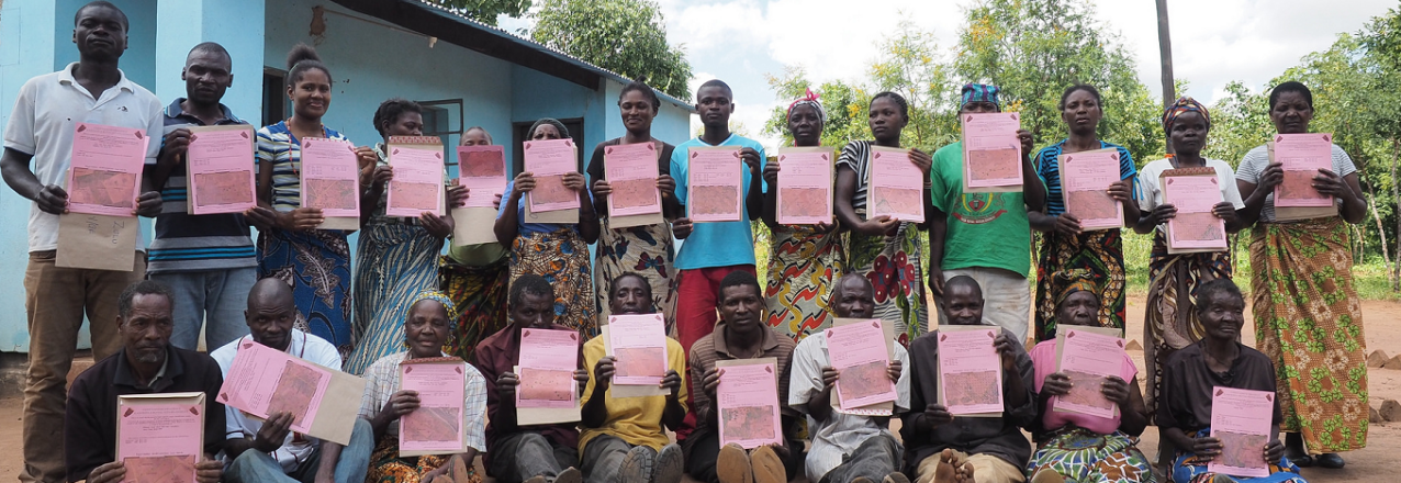
Land tenure and property rights is another emerging area where mobile technology can enhance development in powerful ways.  USAID’s Mobile Applications for Secure Tenure (MAST) initiative is empowering rural communities to define, map, record, and document their land and resources. MAST combines participatory approaches and mobile technology platforms with on-the-ground training to engage communities to map and document land and resource rights through efficient, transparent, and accurate processes. Significantly, these communities are applying this technology more efficiently than more traditional methods and at scale.

The MAST approach is comprised of easy-to-use mobile phone and tablet applications, combined with a robust data management platform, which captures and manages land information that can include names and photos of the people using and occupying land, details about what the land is used for, and information regarding occupants’ claims to land. In addition, on-the ground training of community members builds their capacity to document and manage information about land and resource rights, while participatory approaches ensure that communities understand those rights.

In Burkina Faso, the MAST approach proved to be roughly nine times faster than traditional methods. With MAST tools in hand, and in partnership with the community members, the country’s Rural Land Service required only four months to complete the process of mapping 2,638 parcels in four villages, with verifications averaging 30 minutes each. In comparison, using traditional methods, the same authorities mapped only 3,706 parcels over a four-year period.[2]

By working in tandem with community members—especially youth—MAST enables citizens to map and document their own land and resources in less time, while promoting community autonomy in land tenure processes. For instance, MAST has been implemented on a variety of time scales; the technology can be deployed to map an area intensely for a short time, or more gradually over longer periods of time. Paired with community ownership, this means that the technology is flexible enough to meet the needs of the community.
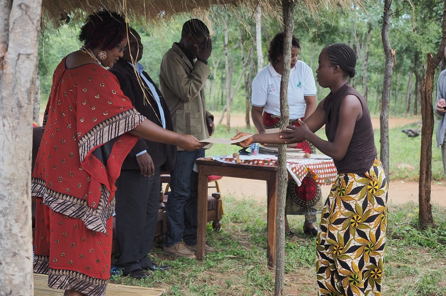
Chieftainess Mkanda distributes land certificates documented through MAST in Zambia’s Eastern Province. Photo: USAID Tenure and Global Climate Change Program.

Efficiencies in mapping are also evident through entire certification processes in Burkina Faso, Tanzania, and Zambia, demonstrating that MAST is a scalable tool. As MAST implementations scale up, the duration between demarcation and certification shortens. MAST allows the certification process to become more efficient as time passes. In contrast, traditional processes generally do not become more efficient over time because of their reliance on older technologies, significant labor, and time-intensive manual processes.

Thus, despite MAST having higher upfront costs related to adapting or customizing the technology suite to specific land tenure context, its significant efficiency gains over time have allowed implementers to leverage mobile tools and citizen-centric approaches for replication and scaling regardless of the context. Ultimately, the MAST approach is not only a rapid and scalable tool, it also becomes more efficient over time as users become familiar with the technology. And this means that land documents get in the hands of the landholders even sooner.

To learn more about MAST, visit USAID’s MAST Learning Platform at:
www.Land-Links.org/MAST or contact Ioana Bouvier (ibouvier@usaid.gov)

[1] Haruna Issahaku, Benjamin Musah Abu & Paul Kwame Nkegbe (2018) “Does the Use of Mobile Phones by Smallholder Maize Farmers Affect Productivity in Ghana?”, Journal of African Business, 19:3, 302-322.
[2] A Mobile Application to Secure Land Tenure, Michael Graglia and Christopher Mellon, Aug. 3, 2017 (https://www.newamerica.org/future-property-rights/blog/mobile-application-secure-land-tenure/);
Issifou Ganou, Medard Some, Raymond Soumbougma, and Anne Girardin, Using Mobile Phones, GPS, and the Cloud to Deliver Faster, Cheaper, and More Transparent Land Titles: The Case of Burkina Faso. Paper prepared for presentation at the “2017 WORLD BANK CONFERENCE ON LAND AND POVERTY,” The World Bank – Washington DC, March 20-24, 2017.

Revealing Identity in a Grain of Cacao

By Land and Rural Development Program in Colombia

Sometimes, social change comes from the most unexpected places. In Tolima, it is coming from the cacao plant. Thanks to a public-private partnership facilitated by USAID, the women from 120 families are walking down the road of equality and are empowered to use their voices. They have realized that expressing their opinions is important, and that their ideas strengthen their families and community.

What began as a training in land preparation, seeding, irrigation systems, and business management gradually became a scenario in which women learned to express themselves and seek to fill leadership roles in spaces traditionally reserved for men.

Yolanda Tapiero, a member of the farmers’ association Asoacas in the municipality of Ortega, never used to participate or speak up in association meetings. She says she was shy and embarrassed to address male colleagues in this professional setting, far from her house.

“The partnership integrated us and taught us to ask ourselves how we worked together. So we abandoned our fear of talking to others. We saw that nothing bad would happen if we expressed ourselves and spoke up. Now, in my association, I request the floor and I propose what I see and what could be useful to the association. We have a lot to say, but it’s because we don’t express ourselves that many things get loss,” Yolanda Tapiero, member of Asoacas, Ortega, Tolima.


Beyond Boundaries: How Secure Land Tenure is Improving Lives in Rural Tanzania

This blog post was originally published on the DAI website.

After Monika Lalika’s husband passed away, her in-laws did not allow her to use the land he had left her and she used to worry that they would one day claim the property for themselves. For Martha Paulo Mwilongo, a land dispute with her neighbor kept her from selling or renting part of her 11 acres to pay her children’s school fees. Joti Kihongo wanted to expand his general store, but could not get a large enough loan because banks would not recognize his undocumented land as collateral.

This lack of official land documentation is not unusual in rural Tanzania, since property in most villages is handed down from generation to generation, typically through male family members. However, for Monika, Martha, and Joti, and thousands of Tanzanians like them, this historically informal system of land ownership had become an impediment to their ambitions.

All that started to change after the Feed the Future Tanzania Land Tenure Assistance (LTA) project began holding meetings in their villages. The U.S. Agency for International Development project works with 41 communities in central Tanzania to register land and issue Certificates of Customary Right of Occupancy to individual landholders, with a focus on increasing women’s inclusion in property ownership. LTA has worked with villages to demarcate and digitally map and record almost 63,000 parcels. These previously undocumented parcels are now registered in the country’s official land registry system, providing secure property tenure to 21,000 Tanzanians. Read the full story

Securing Her Land Rights in Tajikistan

Salomat Choriea Breaks the Mold

This blog post was originally published on Chemonics Impact Stories.

At age 16, Salomat Chorieva started her first job on a farm in Tajikistan. She endured harsh working conditions, growing cotton and wheat on 700 square meters of farmland. She handed over all her harvests to the head of the farm, who undercompensated her for her labor. Working within a land system dating back to Soviet times further complicated her situation: farmers had little control over their land and little knowledge of their rights. Ms. Chorieva seemingly had little upward mobility and no end goal in sight.

At its inception, Ms. Chorieva’s story was not unusual. Agriculture in Tajikistan accounts for approximately 64 percent of employment, and dehkan farms — post-Soviet individual and family farms in Central Asia — are commonly staffed by women, who typically occupy lower-level positions in the agricultural hierarchy. Yet by age 25, Ms. Chorieva broke the mold — she became the first woman in Khatlon province’s Dusti district to head a dehkan farm. She now runs a 27,500 square-meter plot, and her farm boasts harvests of corn, cucumbers, cotton, green beans, and carrots. With her business, she supports her family of six and makes a decent profit. Owning the farm gives her a sense of freedom.

“I have my own money; I can pay my expenses and taxes and divide the profits among family members who work with me,” she explains.

How did Ms. Chorieva achieve this entrepreneurial feat by age 25? While her resilience, motivation, and agency were certainly crucial ingredients to her success, she was not working alone. Her success was facilitated by Aysifat Norbekova, a tashabbuskor (land rights activist), who works with USAID’s Feed the Future Tajikistan Land Market Development Activity (LMDA) to empower local farmers and guide them through the land registration process. Read the full story

The Pride of Plantain

How a public-private partnership is solving several problems for Meta’s plantain growers and winning support in unlikely places.

By Land and Rural Development Program in Colombia

When Meta-based plantain growers’ association Asoplagran made its second shipment of plantain to Grupo Éxito, the Colombian multinational firm returned 30 kilograms of fruit that did not meet its standards. Edilson Aguilar and his colleagues were overjoyed, since they had originally delivered more than three tons.

“Grupo Éxito’s inspectors gave us good feedback and were quite impressed with our plantains,” explains Aguilar. “We are building our relationship with Grupo Éxito. The negotiation is straightforward, and they are not the same type of tyrant you see with traders in the local market.”

Thanks to the PPP, Asoplagran and three additional growers’ associations sat face-to-face with Colombian buyers—including Grupo Éxito and Cencosud—Colombia’s largest food retailers. The business conference, set up by thanks to the Meta Chamber of Commerce, is an example of USAID’s power to convene market players and broker new relationships.

USAID helped create the plantain PPP in early 2018 to leverage government support, gain interest from the private sector, and give producers the chance to continue improving their skills and knowledge. The partnership is valued at approximately US$400,000 (COP1,180 million), includes investments from four municipal governments, and benefits 130 growers from four plantain growers’ associations, such as Asoplagran.


Opinion: Connecting the dots — land rights and inclusive economic growth in Colombia

Last month, top Colombian economic minds gathered in Bogotá for a Grand Economic Forum on attracting investment as the country emerges from a decades-long civil war. Andres Cadena, a senior partner at McKinsey & Company, distilled the issue to its essence: “Colombia’s great challenge is that it has not found its growth model. The country has been growing with an economic model that generates growth, but not well-being. It is not an inclusive model.”

With no shortage of development dollars flowing to Colombia, how can that investment translate into an inclusive model of private sector-led economic growth? And how can the model become self-reliant over time? Read the full story

Under Construction

By Land and Rural Development Program in Colombia

What to do?

Every year, municipal leaders across Colombia face a recurring dilemma: use funds to fix the roads destroyed by the rains or spend the funds on a tertiary road inventory. On the one hand, the inventory is an instrument that every municipality needs in order to get tertiary roads into the nation’s official road network and to access funding. On the other, unmaintained tertiary roads are the first to succumb to Colombia’s violent rains and washouts.

USAID provides municipalities in Tolima with expert consulting, planning tools, and sustainable methodologies to tackle the lack of operational tertiary roads.

Seven out of ten kilometers of road in Colombia are tertiary roads. They are unpaved, ungraded, and usually lack drains, culverts, and retaining walls. For a tropical country dissected by three mountain ranges, the state of a region’s rural roads affects everything from access to education and health to economic development and citizen security. Of Colombia’s 1,120 municipalities, only 32 have completed tertiary road inventories.

Tertiary Roads

The municipality of Planadas, located in southern Tolima, has long been disconnected from the rest of Colombia. It is known as the birthplace of the FARC rebel army and famous for coffee. Until recently, buses took more than 14 hours to traverse the windy dirt road between the regional capital Ibague and Planadas. The municipality currently has more than 390 kilometers of tertiary roads, but according to Colombia’s road authority, INVIAS, there are no more than 26 kilometers.

In 2018, Planadas has COP 800 million to spend on roads. But that can be quickly reduced to nothing when clearing and repairing a rainy-season landslide can cost COP 400 million.

“Just one rainy season can use up the entire annual budget,” explains Niyerith Gonzalez, Planadas city councilwoman.

Gonzalez remembers the last time Planadas hired a contractor to fix a road caught in a landslide. The contractor came from another region of Colombia. Workers got lost, and the contractor brought machinery unable to negotiate the narrow, steep roads. That contract, according to Gonzalez, ended up being a bigger problem than the damaged road.

Bringing Women to the Table

By Land and Rural Development Program in Colombia

When she returned to her land in Morroa, Sucre, Sirle Ruiz never imagined that ñame would be the crop that would help her reactivate her farm’s economy. The tropical tuber was once a mainstay for her family and she remembered how before the violence displaced her family, she helped her father sell it in town.

Farming became complicated when ‘la violencia’—the ongoing conflict between paramilitary, the military, and leftist guerrillas—arrived in the Montes de María region of the Colombian Caribbean. Besides losing their crops and livelihoods, her grandfather, a community leader, and her uncle were killed by guerrilla groups.

“After my grandfather died, my dad sold the plot for less than US$200, which was very little money,” she explained. “We were displaced and this affected us a lot. We were not used to being in the city, because we lived in the countryside.”

In 2014, Ruiz received a favorable land restitution ruling, which recognized their ownership of the land they were forced to abandon, and allowed them to come back to their farm. Since then, Ruiz has been an active member of the Cambimba Agriculture Association.


Reversing Displacement

Since the creation of the Land Restitution Unit, USAID’s support has been integral. What is the current balance of seven years of work between the two entities?

By Land and Rural Development Program in Colombia

With the highest number of displaced persons in the Western Hemisphere, the Colombian government is facing the great task of returning lands to thousands of people. In the post-conflict era, many displaced people have been moving back to the land where they used to work and plant their crops before the violence pushed them out, but the absence of the state and the lack of guarantees for peace continues to cloud their future with doubt.

For the last seven years, the land restitution process has provided legal security for property and comprehensive reparations for displaced people and victims of the conflict. Over this time, the process has benefited more than 38,000 people, recognizing the ownership of some 300,000 hectares.

In the wake of the new administration and a new President, the Land Restitution Unit (LRU), led by Ricardo Sabogal, collected the agency’s historical memory, its main achievements, and the challenges that remain in the restitution process. Last month, the LRU, together with USAID and other partners that have supported the land restitution policy, shared experiences with leaders from other countries and launched the book Memories of the Restitution Process: Lessons Learned and Methodologies for Restituting Lands and Territories in Colombia.

Café Kuma is New Life

By Land and Rural Development Program in Colombia

In rural Colombia, coffee is not only a way of life, but it is also a path out of poverty and toward greater economic self-reliance. With USAID’s support, coffee producers from indigenous communities in Colombia’s Cesar region are improving their capacity to grow and process higher-value speciality coffee. This provides benefits far and wide: for local coffee producers, it means greater income-generating opportunities. For the regional government in Cesar, it means greater domestic revenue generation and local economic growth. And for a U.S. business like Green Mountain Coffee, it means a better and more sustainable supply chain for high-quality coffee.