Results from the 2018 Investor Survey: You Asked, We Answered

USAID LandLinks hosted “The Business Case for Land Rights: Results from the 2018 Investor Survey” on April 5, 2018. The webinar shared findings from the first voluntary Investor Survey on Land Rights and heard from the private sector about live investment projects seeking to create benefits for both shareholders and communities. There were more questions from the audience than could be covered during the webinar. Our panelists, Jeffrey Hatcher of Indufor North America, Finn Jacobsen of African Plantations for Sustainable Development and Oriane Plédran of The Moringa Partnership, along with our moderator Sarah Lowery from USAID, share answers here to some of the most interesting ones.

Question: Might anyone be willing to share the ‘topical outlines’ you may have prepared to guide participants doing participatory appraisals of land issues, in particular regarding mapping traditional land ownership and use? Especially useful might be those used in the West African Sahel/arid zones.

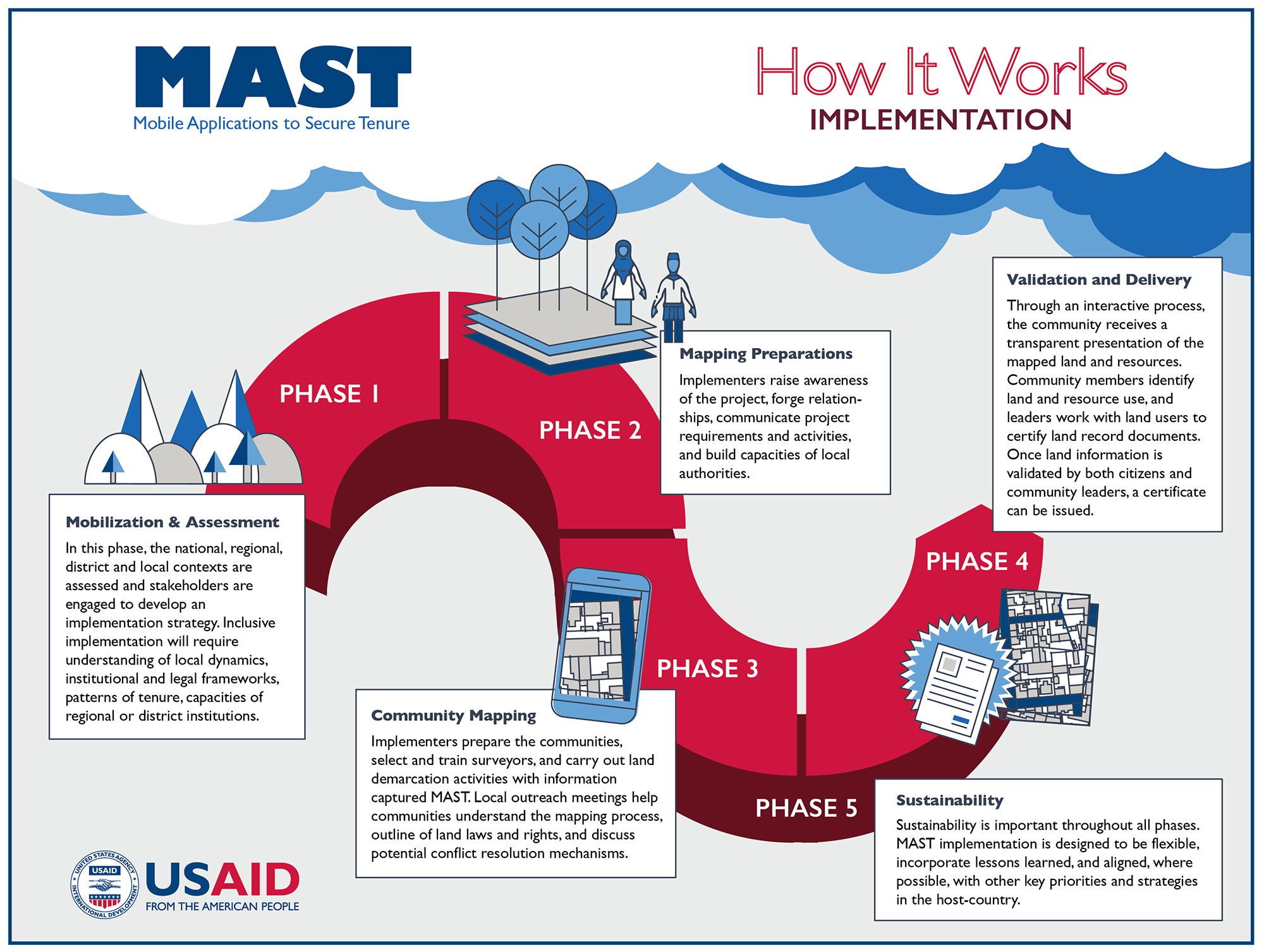
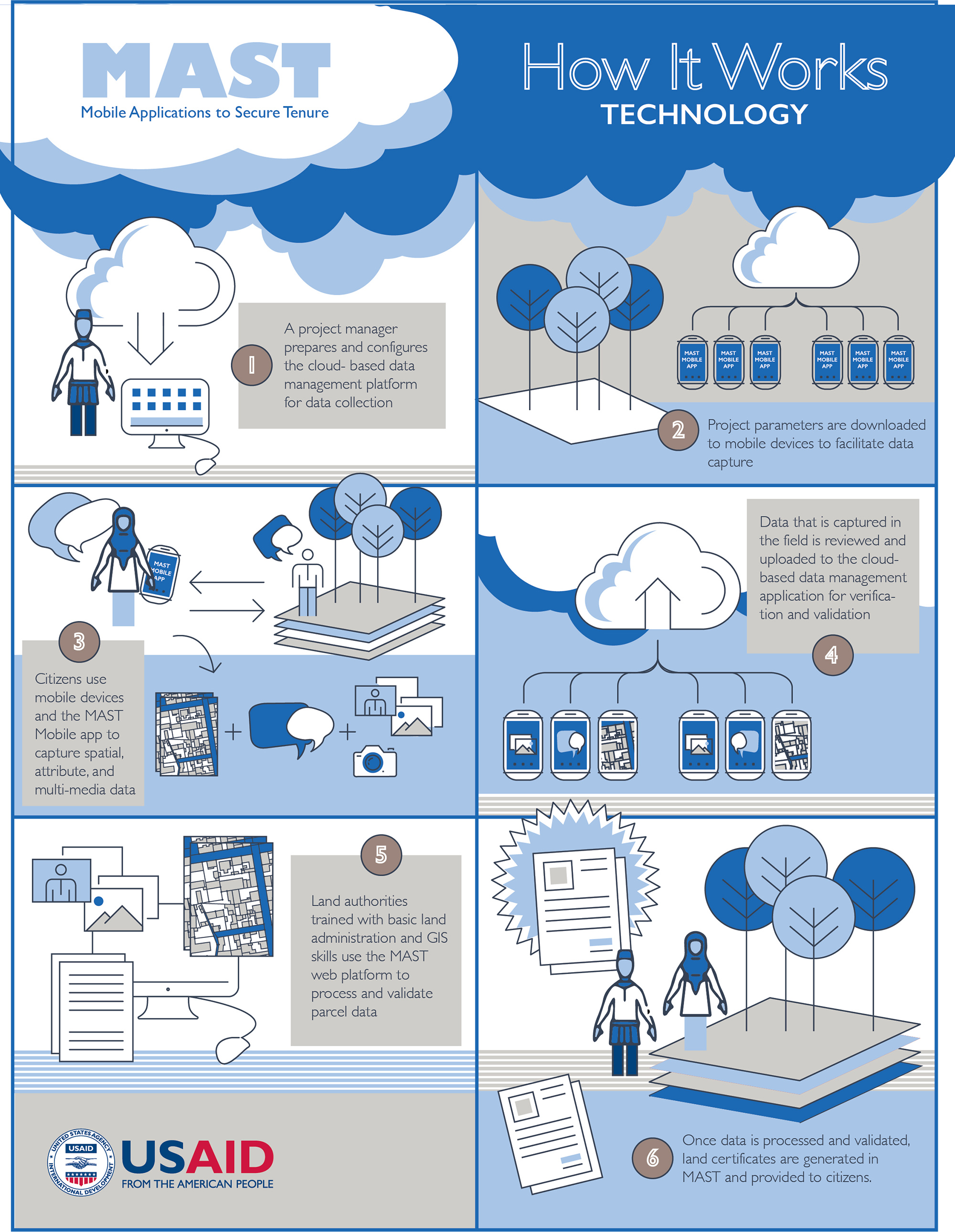
SARAH: LandLinks hosts the Mobile Applications to Secure Tenure (MAST) Learning Platform, which has great resources on the innovative technology tools and inclusive methods that use mobile devices and a participatory approach to efficiently, transparently and affordably map and document land and resource rights. Check out the MAST How It Works Infographic and the Technology Infographic, for example. This New America blog also has a helpful description of the MAST approach.

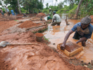
In West Africa/Sahel, USAID has piloted MAST in Burkina Faso with the National Land Observatory (ONF) with some impressive results: in only 25 days, 12 villagers used MAST to map and capture data on 2,708 rural land parcels. ONF’s local publication, “Zoom sur le foncier” (in French, also online), has a section on MAST.

USAID has also worked with MAST in Zambia with customary chiefs to increase tenure security for treatment households, and USAID has demonstrated significant increases in community land governance from participatory mapping, creation of bylaws and related activities under the Community Land Protection Program in Liberia.

Question: The civil society has been supporting the State and the private sectors to increase investment transparency by improving community consultations on land and other natural resources. What mechanisms should be created for local communities to be part of the investments using land as the counterpart?

SARAH: There are many investment models that can create benefits for local communities. These range from 1) lessor/renter agreements where individuals or the community as a whole receive regular payments for use of their land to 2) revenue-sharing arrangements in which the community receives a portion of the revenue or profit of the investment to 3) joint ventures, in which the community actively participates as an equity holder in an investment. The latter can even work if the community does not initially put up capital but borrows its equity stake, to be paid back via the profit from the investment.

FINN: This is a very important question but one with a certain ambivalence. Most of the land owners/caretakers have no or very little income from their land holdings. The main reason for this is that land matters are not managed well and the practice of giving out land plots to settler farmers, etc. is part of the informal economy. An annual lease fee payment will provide a fixed income for the tenure period. If well managed, this will improve their financial situation. Using the land as “equity” will make the land owners shareholders with all the obligations and risks involved, and if the company does not pay dividends the land owners will be stuck without an annual fixed income. I think that a two-stage processwhere they start as a lessor and then when the lease is to be renewed, a participation model could be negotiated, could be a good model. If the land is in the hands of government, an equity stake could certainly make sense.

JEFFREY: Community-centric approaches, such as participatory mapping of land, development of grievance mechanisms, community programs and support to local communities to receive land titles, are essential for diagnosing and addressing land tenure challenges. The level of success of these mechanisms depends on how well the approaches are implemented. Using external service providers or working with local NGOs can be a good way to ensure effective and inclusive community engagement.

Question: How can business approaches and intervention assist in curbing Land Tenure and Property Rights challenges?

JEFFREY: Businesses can integrate land and resource tenure risk assessments into investment decision-making processes to identify the types of risks and possible mitigation actions. Furthermore, they can ensure projects plan and budget to address land tenure challenges, such as recruiting and training qualified staff on best practices for community-centric approaches, including systematic stakeholder engagement, grievance mechanisms, community development programs and participatory mapping of land claims. Additionally, businesses can leverage their existing risk quantification approaches to include better estimates of the land tenure risk impacts on investment returns, as well as quantify the benefits of addressing land risks and engaging communities such as reductions in their cost of capital, increased share price, increased revenue, etc.

Question: A question that probably applies to most projects, but was specifically mentioned by Finn: I refer to the 4 communities of the 10 who responded to the question of what the company could contribute to their communities. I am wondering about your speculations are as to:

  • Why the other six communities did not respond? Was it distrust of an outsider, especially a corporate outsider?

FINN: No, it was not. In the area where we are developing the project, the level of poverty is high and the education level is also below average. We concluded that they actually did not know what to ask for as their needs in general have been so low and they have very limited knowledge of what is possible. Further, the lack of a regular income leads to a passive approach from the local citizens.

  • The request of four for hospitals and schools, even though they had such facilities or access to such. Do you think expected employment was the reason for request of the infrastructure—or something else?

FINN: It was simply the easiest way to answer our request.

Question: I missed how the 5,000 contacts were whittled down into about 75 respondents for Survey 1, and about 100 for another of the surveys. That could cause enormous self-selection, if a result of other companies not bothering to respond…OR some other sort of selection bias, if a result of someone choosing the respondents by criteria other than those listed. I would much appreciate your explaining the selection process.

JEFFREY: For Survey 1, an initial list of approximately 40,000 relevant companies was generated using publicly available sources, which the survey team used to collect contact information for approximately 4,900 individuals working in relevant positions in those companies. The survey team sent personalized invitations to those individuals asking them to complete the survey and followed up with several reminders. A link to Survey 1 was also posted on relevant list-servs and USAID outreach communications.

In total, 143 respondents completed Survey 1. After screening the responses against the qualification criteria, 75 of these respondents were deemed qualified, and their responses to Survey 1 are included in our analysis. These 75 respondents were selected to participate in the second-round survey. Of those 75 qualified respondents, 35 completed Survey 2. Those 35 organizations provided in-depth information regarding 102 projects worldwide, including 39 rejected and 63 undertaken projects in agriculture, forestry and renewable energy. The individuals responding to the survey on behalf of their organizations were all senior executives (C-suite or sustainability officers).

Given the aim and scope of the survey, it is very likely that the organizations that responded to the voluntary survey would have a pre-existent interest, concern or commitment to responsible land-based investment. Additionally, the number of respondents from Asia and Oceania was relatively small compared to those from other regions. This report, therefore, only makes claims regarding the organizations that participated in the survey. It should not be interpreted as representative of organizations outside the sample, nor does it try to draw generalizations about land-based investment as a whole.

Despite numerous efforts to generate as many participants as possible, the final sample size of the survey was modest. The response rate may have been affected by several factors. Given that this is the first edition of the survey, there was no reference point for potential respondents. The request for detailed operational information and length of Survey 2 may also have dissuaded some potential respondents. In addition, the timing of the survey—launching in late 2017 with data analysis in early 2018—coincided with several holidays, and the short timeframe limited possible follow-up efforts. The branding of the survey from USAID—a public institution—might have dissuaded some private company responses due to the sensitive nature of the questions. Lastly, many emails bounced back, ended up in spam folders or were never opened. It is notable, however, that once the survey was started, 77 percent of potential respondents completed the survey.

Question: Work needs to be from the ground, the “bottom-up” approach with “top-down” support. However, in our experience, the chiefs were not sufficiently “on the ground.” Much too often, their personal benefits took precedence over those of the community. Did you encounter problems of chieftaincy corruption and [if so,] how did you deal with it?

FINN: The level of corruption in the areas we are operating is low. We also informed all stakeholders from the beginning that we have a no corruption policy. In the beginning they still tried to ask for certain personal favors which we always declined. If they asked us to grade the road in a community, however, we agreed to do that. All stools have no approved mapping of the stool area, and previously the boundaries were described by large trees, creeks, large stones etc., but most of these “landmarks” have disappeared. It is always a challenge on how to split up the lease fee paid by African Plantations for Sustainable Development. The stool itself and the traditional council receives approximately 40 percent of the gross lease fee. One of our Stools has agreed to split the fee in three parts, one third each to the traditional council, the community and the youth organization.

Question: Could you please explain how you can or do attempt to work with customary or traditional stakeholders to partner with them so they can become better stewards of the environment in Ghana?

FINN: This is a huge challenge and we are talking about changing old habits and bad agricultural practices. Where we find these high levels of poverty there is no understanding [of or concern for the] environment, conservation and reduced burning. Our concept is to show as many farmers and stakeholders as possible that it is possible to do agricultural activities without destroying everything around you, but it certainly takes time. As I stated in the webinar, there is much talk about land use, but almost none concerning land abuse and the latter is a more serious challenge. Climate smart agriculture is one of the key concepts but that will also take time as it is still too much patchwork and not enough solid concepts around.

Question: What would you consider as the main responsible land business standard? It seems that the Interlaken Group consider the VGGT as the primary one.

JEFFREY: Indeed, the Interlaken Group has defined its view on company responsibilities to uphold the VGGT in commercial settings through its release of the Interlaken Guide on Respecting Land and Forest Rights. In addition, almost all governments have committed to the VGGTs, which require them to respect legitimate land rights.

However, Indufor does not consider one guideline as the main responsible one, since the different guidelines focus on different aspects of land-based investments, such as agricultural projects, or inclusion of human rights. Overall, the challenge is for companies, operating in a variety of governance contexts, to put these guidelines into practice and internalize the guidelines’ principles. To do so, Indufor sees a need to iteratively improve these guiding principles over time, rather than calling for project abandonment as currently outlined in some of the guidelines and frameworks.

SARAH: Similar to Jeff’s response, USAID does not see one particular guideline as better than others. I personally like the Analytical Framework for Responsible Land-Based Investments in African Agriculture because it is succinct (~16 pages), clear and practical. Of course we also have the USAID Operating Guidelines for Responsible Land-Based Investment.

However, I would argue that it is much more important that investors and businesses are seeking to create projects that respect local land and resource rights and that benefit local peoples. If guidelines are helpful in achieving that end, fantastic.

Question: What tools are available to support global business operating in weak land governance context to adopt full land and property rights due diligence strategy?

JEFFREY: There are several tools to assist any company to perform a due diligence assessment. Some of these tools might be required by law, such as environmental and social impact assessments (ESIAs), and are often conducted by a third party. Other tools are additional, including an initial diligence assessment, participatory mapping, checking titles and land rights documents, which can also be performed by a third party.

In the Investor Survey, we found that of the tenure risk mitigation strategies reportedly used in undertaken projects, those perceived as being successful in more than half of reported projects focused on stakeholder engagement, community development programs, participatory mapping of land rights, establishment of grievance mechanisms and support to local communities to obtain land titles. The strategies that succeeded in fewer than half of reported projects included working with government authorities, installing guards to protect plantations, employment of local community members and building fences around plantations. Approaches used in the case studies include providing impartial legal assistance to local stakeholders for contract negotiations and providing technical assistance to strengthen farmer interest and participation in out-grower models.

A Look Back at the 2018 World Bank Land and Poverty Conference

Last month’s Annual World Bank Conference on Land and Poverty brought together over 1,200 participants from across the globe—including representatives from governments, academics, civil society and the private sector. It includes discussions of new research, innovations, practices and policies to strengthen land and resource governance.

USAID presented on key findings and lessons learned in land matters from across the globe, including responsible investment, land and customary tenure, sustainability, economic growth, women’s empowerment and much more. You can view the presentations and download papers from USAID and our implementing partners on this event page.

Blogs from USAID and our Partners Published for the 2018 Land Conference:

USAID also participated in a high-level round table discussion entitled “Regularization of Rural Rights: Lessons Learned from Ethiopia, Liberia and Zambia” that featured speakers from USAID, the Ethiopian Ministry of Agriculture, the University of Zambia, Namati and the Liberia Land Commission.

Highlighted below are three of the posters that hung during the conference, featuring additional cutting-edge research and key-findings from USAID projects across the globe.

Data used in the posters and the presentations and papers can be found on LandLinks and is available in the Evaluations and Research section of the site.

Additionally, be sure to view this data visualization from a rigorous impact evaluation of the Tenure and Global Climate Change (TGCC) project in Zambia (2014-2017).


USAID Posters Presented at the 2018 Land Conference:

Gender, Resource Rights, and the Role of Customary Authorities: A Multi-Site Study of Women’s Empowerment in Customary Settings

By Heather Huntington, Adi Greif

This poster explores the relationship between customary governance, customary tenure security and women’s empowerment using two large-scale representative surveys from Zambia and Ethiopia.

The Role of Property Rights in Technology Adoption: Evidence from a Randomized Controlled Trial

By Heather Huntington, Ajay Shenoy

This poster provides rigorous, microeconomic evidence on whether weak property rights prevent households from adopting new technology. We evaluate USAID’s Tenure and Global Climate Change (TGCC) intervention in Zambia that cross-randomized an agroforestry extension with a program to secure customary land tenure to smallholder farmers.

Evidence to Inform Liberia’s Land Policy: Evaluation Findings from Namati’s Community Land Protection Program

By Kate Marple-Cantrell, Heather Huntington, Alexandra Hartman

This poster presents midline results from a rigorous evaluation of the Community Land Protection Program (CLPP) in Liberia. CLPP supports communities to leverage community land documentation processes for positive intra-community changes, leading to enhanced local empowerment, resource governance, and livelihoods.

USAID Improves its Innovative Technology to Strengthen Land Tenure: MAST

USAID’s Land Technology Solutions Project (LTS) has recently completed a comprehensive update to Mobile Applications to Secure Tenure (MAST) which uses innovative technology, including GPS enabled phones and tablets, to efficiently and effectively document land rights. Countries, communities and companies interested in meeting their commitments to establish deforestation-free value chains, boost agricultural productivity, quickly inventory land and document holdings or clarify and document land uses can now harness a much-improved suite of tools to expedite their work.

LTS now provides a suite of integrated support services to USAID Missions to promote and scale the use of MAST worldwide. LTS services focus on meeting the needs and interests of USAID Missions and their implementing partners to achieve host country strategic development objectives, including those outlined in the Global Food Security Strategy, the USAID Gender Equality and Women’s Empowerment Policy, and the USAID Biodiversity Policy. The tool is yet another example of how USAID works as a catalyst to help others, including civil society, corporate partners and other governments, expedite their efforts to achieve development goals and create a durable path out of poverty.

What is MAST?

USAID’s MAST is a suite of innovative technology tools paired with inclusive training and approaches that use mobile phones and tablets to efficiently, transparently and affordably map and document land and resource rights. MAST can help people and communities define, record and register local land boundaries and important information, such as the names and photographs of people who use the land and information about how they use it. MAST combines an easy-to-use mobile phone application with a participatory approach that empowers citizens in the process of understanding, mapping and registering their own rights and resources.

The MAST application provides a suite of tools to support the collection and management of land rights information, including a mobile application to capture land rights information in the field and a back-end land rights data management application with tools to manage an inventory of land information. MAST Mobile is an Android mobile application.

Since 2014, MAST has been used by stakeholders in Tanzania, Zambia and Burkina Faso, to clarify and document claims to land. In these countries, MAST has provided transparent and effective mechanisms to improve land governance, build institutional capacities, engage citizens and help them understand their rights and responsibilities.

Enhanced Technology

Over the last eight months, LTS has refined and improved MAST technologies and approaches. LTS has updated key components of the MAST software application framework and upgraded the MAST data model from Social Tenure Domain Model (STDM) to more common standard Land Administration Domain Model (LADM). With an updated Data Model, MAST is now more compatible with models used in larger, more formal land administration or registration systems.

Enhanced Land Record Management

A more robust land registration module has been integrated into MAST based on feedback and lessons learned in Tanzania and Burkina Faso. In these countries, users identified the need for a land registration module. This has been integrated and configured to manage a series of prototypical subsequent land registration transactions such as transfers, sales, leases and mortgages. The modular nature of its integration into MAST provides enhanced functionality, and an important base for country-specific customization, but doesn’t reduce its flexibility and responsiveness for community mapping.

Improving Efficiencies and Eliminating Errors

To improve data capture of individual land holdings, a tasking and data collection manager has been implemented in MAST. The tasking manager does away with the need to manually assign work areas to surveyors and uses integrated geospatial tools. Integrated tools allow users to define and assign work allocation units to surveyors to increase efficiencies and avoid capture of redundant data. To further address issues associated with online data management and mapping tools on slow and unstable internet connections, a QGIS plugin has been modified to be used with MAST. Integrating QGIS tools allows administrators the ability to download geospatial data, utilize QGIS to edit data in offline mode and to sync data back to the main MAST database. Such editing functions have been augmented by the integration of topology tools that can be used to flag and check errors.

Extending Tools for Resource Management

The MAST mobile application has also been updated. The parcel mapping tool has been extended to incorporate tool sets derived from USAID’s Land Tenure Assistance program in Tanzania, which extended MAST to include more robust data editing functions and to document new, existing and/or disputed claims to land. MAST mobile has also been linked via Bluetooth connection to several consumer-grade GPS tools to improve accuracy of mapping available on native mobile devices. Most importantly, MAST Mobile has recently been extended to include a resource mapping module. The resource mapping module uses a hybrid land classification system to collect resource information such as point of interest, road networks, forest areas or water bodies to enrich the base data in MAST and the availability of data to communities.

Continued Deployments, Continued Refinements

These improvements to MAST will enable users to capture and process land and resource rights more efficiently, although MAST still requires technical knowledge and advanced skills to set up and configure.

As the suite of tools is used in other geographies and for new purposes, LTS will incorporate new features and/or improve existing ones. And as an open source project, MAST will be continually improved upon and updated. LTS will maintain a core MAST platform and incorporate the best of these improvements.

LTS will continue to work across organizational boundaries to make MAST a truly global tool, and an empowering experience, to address land tenure insecurity.

Chengue Dances

A 2016 land restitution sentence brought little solace, but when government agencies began delivering on orders, despair turned to joy and inspired a party in this forgotten village.

Originally appeared on Exposure.

For the last seventeen years, residents of Chengue have found few reasons to dance. They fled their small village in the heart of the tropical hill country of northern Colombia after living through a bloody massacre perpetrated by a group of paramilitaries in 2001. That day, 60 uniformed killers ended the lives of 27 villagers with hammers, rocks, and machetes, and burned down dozens of houses. They told the survivors to never return, because from that point forward.

FIESTAS PATRONALES

In 2017, hundreds of Chengueros proved their attackers wrong and organized the first fiestas patronales in more than 20 years. On the same plaza where their fathers, brothers, uncles, and cousins were killed, residents danced to the local rhythms of porro and gaita music. The historic festivities—held in the first week of July—were colorful scenes of people dancing, women stirring pots of sancocho (turkey soup), poker-faced elders playing cards and drinking beer, excited children flipping marbles on the roads, and agile horseback riders on display.

The fiesta was the latest attempt by Chengue families to show one another that their former lives are not gone—rather, those two-day bacchanals that once made Chengue famous are back with the same pomp and pageantry of days past.

Chengue is located in the region known as Montes de María, where, following the demobilization of Colombia’s brutal paramilitary groups in 2008, the government began the slow process of land restitution and reparations for victims. A decade after the massacre, the government created the Land Restitution Unit (LRU), which has set out to recognize the land rights of victims, provide reparations, and allow victims to return to their homes and their lives. More than 10,000 people who survived the violence and were forced to leave their homes have since processed land restitution claims with the LRU.

By the time the LRU was created, the more than 300 Chengueros had nearly lost all hope for any justice related to the massacre, a tragedy that, in their eyes, seemed tethered to a corrupt and bureaucratic system. In 2006, a local judge determined that the police and the Colombian armed forces did not do their job to prevent the attack, awarding a settlement of more than US$1 million. Eventually, approximately 100 surviving families were paid around US$10,000 each, a paltry sum compared to the amount the court originally awarded. Then In 2008, the man who had ordered the massacre, Juancho Dique, was sentenced to just eight years in prison as part of the government’s paramilitary demobilization program; He was released in 2015.


Announcing the Release of LandPKS 3.0

The Land Potential-Knowledge System (LandPKS; landpotential.org) team is happy to announce that we have released a new and improved version of the LandPKS app.  This new version is a result of months of hard work for everyone on our team, as well as helpful feedback from our users around the world.  The LandPKS app helps users make more sustainable land management decisions by assisting users to collect geo-located data about their soils, vegetation and site characteristics; and returning back to users useful results and information about their site.  It also provides free cloud storage and sharing, which means that you and others can access your data from any computer from our Data Portal at portal.landpotential.org.  The LandPKS app does not require a data connection to be used, and users can upload their data when they next have connectivity. The LandPKS app includes two modules: LandInfo and LandCover.  The LandInfo module walks a user through how to determine the texture of their soil, which is critical information for smallholder farmers and can help them plant crops suitable to their soil type.  The LandCover module walks a user through how to collect vegetation cover data, important for vegetation monitoring and ecosystem restoration. The LandPKS app Version 3.0 is free and available now on the Google Play Store and iTunes Store.

What’s New?

  • Updated and improved user interface
  • Easy navigation between data input and report (results) screens
  • Graphical LandCover results including cover trends over time
  • Graphical LandInfo results with a table of texture and rock fragment volume by depth
  • Available Water Holding Capacity and Infiltration calculations for your soil
  • Upload data to the Data Portal at any time by hitting the “Synchronize Now?” button

Other Improved Features Include:

  • A simple, primarily graphics-based interface that minimizes language and literacy requirements
  • Embedded tutorials and explanations to guide the user through the app
  • Offline data collection
  • Unlimited access to stored data via our Data Portal at http://portal.landpotential.org

Learn more about the LandPKS app on the landpotential.org website.  Training resources, including guides and online trainings, are also available on the website. The LandPKS app was developed by the LandPKS Team for the Land-Potential Knowledge System (LandPKs) with support from USAID and USDA-ARS.   Please contact us at contact@landpotential.org with any questions, comments or feedback.

Land Matters Media Scan – 13 April 2018

Here are the recent land tenure and resource management media items:

USAID

  1. This April, Agrilinks and Landlinks Team up on Land Tenure for Food Security (3/28/18)
    Source: Agrilinks
  2. Lessons in Land Tenure: Programming in Practice – mentions LGSA, TGCC Burma, LTA Tanzania, & the recent Ilovo responsible land-based investment webinar (4/3/18)
    Source: Agrilinks
  3. Feed the Future Global Food Security BAA (4/10/18)
    Source: Agrilinks

Upcoming Events

  1. Open Contracting in Land: Finding a Way Forward Brown Bag Lunch (4/23/18)
    Source: OpenGov Hub
  2. Overcoming Gender Barriers to Accessing and Using Climate Information Services (4/25/18)
    Source: Agrilinks

Reports and Publications

  1. FAO Land Resources Planning Toolbox Available on the Web (4/2/18)
    Source: Agrilinks
    Related report: Land Resources Planning Toolbox
  2. Land Corruption Hits Women Farmers Hardest (4/6/18)
    Source: News Deeply
    Related report: Women, Land and Corruption: Resources for Practitioners and Policy-Makers
  3. Responding to land-based conflict in Ethiopia: The land rights of ethnic minorities under federalism (3/29/18)
    Source: Oxford African Affairs
    Related report: Responding to land-based conflict in Ethiopia: The land rights of ethnic minorities under federalism

Global

  1. Land and Natural Resources Tenure: Rights and Policy Challenges (4/10/18)
    Source: Agrilinks

Indigenous Peoples

  1. Bangladesh: Indigenous People of Plains: Forming land commission not enough (4/6/18)
    Source: The Daily Star
  2. Brazil averts “a massacre” by blocking eviction of Indians (4/11/18)
    Source: Thomson Reuters Foundation
  3. Cameroon: Rubber plantation in Cameroon edges closer to UNESCO World Heritage Site (4/6/18)
    Source: Mongabay
  4. Ecuador: ‘Our territory is our life’: one struggle against mining in Ecuador (4/9/18)
    Source: The Guardian
  5. Indonesia peatland swap plan questioned over deforestation risk (4/6/18)
    Source: Thomson Reuters Foundation
  6. Peru: Uncontacted tribes’ rights recognized in Peru’s historic land pledge (4/5/18)
    Source: Survival International
  7. Philippines: Land tenure issues in Boracay (4/12/18)
    Source: The Manila Times

Africa

  1. Burkina Faso: Deutsche Welthungerhilfe launches a land tenure project for small-scale farmers (4/6/18)
    Source: Ecofin Agency
  2. Côte d’Ivoire: Government launched a project to reduce rural land conflicts (4/4/18)
    Source: Ecofin Agency
  3. South Africa: DA Resolution Rubberstamps Opposition to Land Expropriation Without Compensation (4/7/18)
    Source: Eyewitness News
  4. Tanzania: Branded as Witches, Stripped of Land: Tanzania’s Widows Need Support – written by Landesa’s Monica Mhoja (4/12/18)
    Source: News Deeply
  5. Zimbabwe: Gold miners in Zimbabwe seize Grace Mugabe’s farm amid land dispute (4/9/18)
    Source: TRT World

Americas

  1. Colombia: 8 police killed in attack on land restitution commission in northwest Colombia (4/11/18)
    Source: Colombia Reports

Asia

  1. Cambodia: Nearly 300 families living on islands given land titles (4/6/18)
    Source: Khmer Times
  2. India: Thousands of Farmers March to Shimla, Demand Land Rights (4/3/18)
    Source: The Wire
  3. Pakistan: Fishing communities protest against occupation of their land (4/6/18)
    Source: The Express Tribune
  4. Thailand: Rights in poorer nations must be upheld as Thai firms go abroad, activists say (4/10/18)
    Source: Thomson Reuters Foundation

Pacific

  1. Hundreds gather in Samoa to protest about land rights (4/11/18)
    Source: Radio New Zealand

Land Matters Media Scan – 6 April 2018

Here are the recent land tenure and resource management media items:

USAID

  1. Webinar: The Business Case for Land Rights: Results from the 2018 Investor Survey (4/5/18)
    Source: USAID LandLinks
  2. Webinar: Private Sector Perspectives on Responsible Land-Based Investment, Part II (3/8/18)
    Source: USAID LandLinks
    Related: Private Sector Perspectives on Responsible Land-Based Investment: You Asked, We Answered
  3. USAID and IUCN Partner to Advance Gender in the Environment (3/23/18)
    Source: USAID LandLinks
  4. Colombia: Land Front and Center in Colombia (4/2/18)
    Source: USAID LandLinks
  5. Lessons Learned on Responsible Land-Based Investments in Mozambique – mentions Sarah Lowery (3/1/18)
    Source: Indufor
  6. Kenya: When the Maasai met the Maori: Kenya seeks to end geothermal land conflicts – mentions Power Africa (3/19/18)
    Source: Thomson Reuters Foundation
  7. Liberia: Historical Injustices Should Be Addressed by Land Authority – mentions USAID’s LGSA project (3/22/18)
    Source: Daily Observer

Upcoming Events

  1. 3rd Asia-Pacific Rainforest Summit (4/23/18 – 4/25/18)
    Source: CIFOR

Reports and Publications

  1. Governing Land Investments: Do Governments Have Legal Support Gaps? (3/19/18)
    Source: Columbia Center on Sustainable Investment
    Related report: Governing Land Investments
  2. Women short-changed on commercial land deals in Africa – report (3/20/18)
    Source: Thomson Reuters Foundation
    Related report: A Fair Share for Women: Toward More Equitable Land Compensation and Resettlement in Tanzania and Mozambique
  3. Managing mining for sustainable development – A Sourcebook (3/20/18)
    Source: UNDP

Global

  1. Legal activism key to securing land rights during new investment phase (3/20/18)
    Source: Land Portal Foundation
  2. Announcing the launch of the Research Consortium on Women’s Land Rights (3/23/18)
    Source: Land Portal Foundation
  3. A new global benchmark may reduce land conflicts (3/23/18)
    Source: The Business Times
  4. 10 years on, tenure remains a challenge for REDD+ (3/27/18)
    Source: CIFOR
  5. Up for grabs: How can we use our land sustainably? (4/3/18)
    Source: United Nations Environment Programme
  6. Agroforestry: Why don’t farmers plant more trees? (4/4/18)
    Source: CIFOR

Indigenous Peoples

  1. When rights to land doesn’t mean rights to resources (2/26/18)
    Source: CIFOR
  2. Brazil’s Land Battles (3/5/18)
    Source: World Policy
  3. In eastern Indonesia, a forest tribe pushes back against miners and loggers (3/5/18)
    Source: Mongabay
  4. Ecuador: Keep off our land, indigenous women tell Ecuador’s president (3/23/18)
    Source: The Guardian
  5. Peru: Isolated Tribes and Forests Threatened by New Amazon Road (3/23/18)
    Source: National Geographic
  6. Tech and collaboration are putting indigenous land rights on the map (3/26/18)
    Source: Mongabay

Africa

  1. Cameroon: Legal activism key to securing land rights during new investment phase (3/20/18)
    Source: Thomson Reuters Foundation
  2. Kenya: 3,000 Ogieks evicted from forests to get land title deeds (4/1/18)
    Source: The Star
  3. Liberia’s new president must lead on land rights or risk conflict (4/3/18)
    Source: Thomson Reuters Foundation
  4. Senegal: Senegal city races to move families as sea swallows homes (4/3/18)
    Source: Thomson Reuters Foundation
  5. South Africa: ANC studies new tax to help drive shift in land ownership (4/3/18)
    Source: BusinessDay
  6. South Africa: Land reform policies criticised at HRC inquiry (3/29/18)
    Source: GroundUp
  7. South Africa: Expropriation Without Compensation: This Is The Legal Framework (2/27/18)
    Source: Huffington Post South Africa
  8. Tanzania: Women’s Land Rights and Sustainable Development Goals in Tanzania (3/1/18)
    Source: SDGFunders
  9. Togo: The MCC approved a $35 million threshold program with Togo (4/4/18)
    Source: Togonews
  10. Uganda: ‘Buying air’, or how not to invest in land in Uganda (4/4/18)
    Source: Thomson Reuters Foundation
  11. Uganda: Forgotten Women: How one woman is fighting against the brutal Uganda land grabs (3/7/18)
    Source: The Independent
  12. Zambia Should Protect Customary Land Rights (3/27/18)
    Source: Human Rights Watch
  13. Zimbabwe: Widows, land and power (3/19/18)
    Source: Thomson Reuters Foundation

Americas

  1. Brazil: Slaves’ descendants in Brazil braced for long fight for land titles (3/6/18)
    Source: Thomson Reuters Foundation
  2. Colombia: Understanding the causes of Colombia’s conflict: land ownership (4/3/18)
    Source: Colombia Reports
  3. Latin American countries sign legally binding pact to protect land defenders (3/6/18)
    Source: The Guardian

Asia

  1. Cambodia: A People in Limbo, Many Living Entirely on the Water (3/28/18)
    Source: New York Times
  2. Cambodian farmers sue Thai sugar group Mitr Phol over alleged land grab (4/2/18)
    Source: Thompson Reuters Foundation
  3. India: Eight land-related topics that need to be prioritized and urgently addressed in India – written by Tim Hanstad (2/23/18)
    Source: Land Portal Foundation
  4. India: Landesa’s Chris Jochnick: Property rights raise a woman’s self-confidence – written by Chris Jochnik (3/10/18)
    Source: Livemint
  5. Mongolia: Property rights in Mongolia: Making space for women? (3/8/18)
    Source: Land Portal Foundation
  6. Philippines: Coffee conquers conflict for business-savvy farmers in the Philippines (4/3/18)
    Source: Thomson Reuters Foundation
  7. A Viral Revolution: Land Rights and the Arab Spring (2/20/18)
    Source: Land Portal Foundation

Webinar: The Business Case for Land Rights: Results from the 2018 Investor Survey

This webinar shared results from The Investor Survey on Land Rights and provided evidence that investors quantitatively and qualitatively account for land risks in their investment decisions and actively work to mitigate potential land risks, and that when land risks materialize, there can be large financial impacts. The webinar also looked at successful business models that have been deployed to reduce risks for investors and provide benefits to local communities, also highlighted in the survey and report.

Thursday, April 5, 2018
8:00 – 9:00 am EDT

Private Sector Perspectives on Responsible Land-Based Investment: You Asked, We Answered

USAID LandLinks hosted a webinar on “The Business Case for Land Rights: Private Sector Perspectives on Responsible Land-Based Investment” on March 8, 2018. Due to the high level of interest, there were more questions from the audience than we were able to answer. We share here answers to some of the most interesting questions, to which our panelists, Larry Riddle, Kate Mathias and Felizardo Mogole, from Illovo Sugar Ltd., along with the webinar moderator, Sarah Lowery, from USAID, took the time to respond:

Question: Can Larry or Kate speak to how long the pilot took and how Illovo managed internal tensions regarding the time investment required for this in-depth, participatory process vs. other business priorities and time constraints or imperatives?

KATE: The pilot with USAID was for 18 months; however, our broader land rights program is on-going, and we do not foresee an end to it. There are challenges around time management when engaging in the programs; however, we view land rights and land management as integral to the business and develop clear business cases for engagement. This particular pilot focused on empowering community members to be able to undertake the participatory mapping through the growers’ cooperative with support from Illovo, USAID, and Terra Firma, and we believe that this is the most sustainable and effective way of implementation and helps to build the capacity of the local enumerators and cooperative leadership whilst reducing the impact on employee time.

Question: When documenting land rights, what is included on the document, and how is this information obtained, and where is it recorded?

FELIZARDO: The project beneficiaries were requested to show a formal identity document of some form, as long as it contained information such as name, age, residence. The documents were requested during sensitization sessions, which were conducted by trained enumerators from the community. In the cases where a beneficiary had no documentation, they would be requested to bring witnesses who would corroborate their statements. The data would then be captured on a digital form that would be sent to a database housed at Terra Firma (soon to be relocated to the cooperative). A formal ‘corrections and objections process’ was incorporated into the process to provide opportunities for grievances to be tabled and resolved if possible before certification.

The land document includes:

  • Name
  • Gender
  • Birthdate
  • Identification Type, and Number
  • Issuance date
  • Delimitation date (of mapping)
  • Witness name
  • Edict date and term limit
  • Date of signature
  • Parcel #, district, postal code, etc for map
  • Area and latitude/longitude for parcel

Question: Does the investor (e.g. Illovo Sugar) negotiate with individuals or with communities? If the former, how are the rights of the community respected? And if the latter, how is community membership defined, and how do the economic and social benefits of the investment reach individuals within the community?

FELIZARDO: I am not sure I understand what is meant by “negotiation with individuals or with communities” since this is a process that follows a Free Prior and Informed Consent for the free-of-charge land mapping and registration to obtain a certificate of occupancy; i.e., community members will continue farming their land in their preferred manner either individually or through their original associations, be it for sugar cane or food crops. The benefit they receive from the project is that now their land rights are registered. As previously mentioned, the process was implemented by community-based enumerators in line with legal requirements, so Illovo did not directly negotiate with landowners; its role was more as a facilitator along with our partners (Terra Firma, Indufor N.A., Cloudburst Group).

Question: How did Maragra ensure the sustainability of the project learnings among the outgrowers?

KATE: By running the project in partnership with the growers’ cooperative, we have assisted in building their capacity to sustain the project and have included training around land rights into our broader extension and capacity building programs. Additionally, we have retained Terra Firma, our local implementing partner who led the participatory mapping and documentation, on contract to continue to support the cooperative and its ongoing work on land.

Question: The women and men in my mining community and around the county want agricultural programs that work in customary rights systems. Both women and men lack food security and economic empowerment. I am a licensed diamond miner and diamond broker since 2013. Women and men in Gbarpolu County, where I mine, and throughout rural Liberia, usually have customary rights to land. I would like to know:

  1. How Mr. Felizardo Mogole implemented the land rights guidelines with specific reference to an example of how Illovo’s participatory mapping process model (a la Terra Firma) helped customary rights farmers strengthen their tenure security?

FELIZARDO: The whole process of strengthening tenure security started with a sensitization stage involving government officials and local authorities as well as beneficiaries from the communities. We also involved the project beneficiaries in training on land legislation and their rights, and they were integrally involved in the participatory mapping of their own and neighbors’ lands. They also had the chance to look at maps of all the parcels and the personal information that would be included on their land rights certificate. This gave them a chance to discuss and compare among their peers and also consult with neighbors to ascertain the validity of the information prior to its approval.

  1. How would the Illovo pilot be modified to work in countries like Liberia where urban farmers have no formal land ownership documents and have been granted the right to use land by a town chief, for example?

SARAH: Jumping in from the USAID Land and Urban office – the participatory mapping approach that we implemented in Mozambique with Illovo can be applied to any context. We use a suite of innovative technology tools and inclusive methods that use mobile devices and a participatory approach to efficiently, transparently and affordably map and document land and resource rights. In the Liberia example you cite, this approach would be based upon a needs assessment including the town chief and other relevant government officials and/or customary leaders to determine their interest and support for giving land documentation to landowners.

This is similar to our work in Zambia with customary chiefs that increased tenure security for treatment households, and USAID has demonstrated significant increases in community land governance from participatory mapping, creation of bylaws and related activities under the Community Land Protection Program. One caveat is that our approach would likely need to be adapted to a context with greater population density, such as a village or town, as the preciseness of the mapping would need to be higher than in rural areas.

Question: On land for food use, is there a balance between land being used by the growers in the region for food and for cane? How is Illovo minimizing the risks and adverse impacts of monocropping?

KATE: The project with USAID registered all land in the selected blocks whether the land was under sugarcane or other crops. The local communities are encouraged to choose whether they would like to supply sugarcane to Illovo, and there are clear procedures to enable growers to register or grow sugarcane, which include environmental suitability checks. The project with USAID, along with a number of comprehensive studies, has assisted the growers’ cooperative and Illovo to better understand the land situation and work with the communities on land use planning.

Our separate grower development project, the Maragra Smallholder Sugarcane Development Project (MSSDP), supports the development of infrastructure and water management processes that will protect over 3,000ha of community land that has been underutilized due to annual flooding since the year 2000 when El-Niño floods changed the river flows and drainage. MSSDP seeks growers to produce cane on approximately 1540ha and supports organized food crops or alternative crops on 460ha; the remainder of the land is developed by the community members as they please. The project commenced with very comprehensive civic education, which assisted the growers to understand the project, its opportunities and make choices around their involvement and their land use. Some associations and individuals decided to incorporate very little of their land into sugarcane and others a larger percentage. It is entirely their own decision.

Question: Do you think that community land-based information and planning before any investors’ intervention would make it easier to investors to engage with rural communities when it comes to land-based investments? Can it improve community consultation?

KATE: Yes, I do. It would provide investors with better information to ensure that they consult with the right parties, and it would empower communities to better understand their rights and protect against potential land grabs. I believe it will improve community consultation and negotiation for all, as community members will come to the table with more security, understanding and power over their choices.

Question: You [Kate] quoted land titling theory (improved tenure security brings about economic investment and reduces poverty) but this has been shown to be a tentative relationship at best in sub-Saharan Africa, possibly because of the multi-generational relationship of land rights-holders to land. How do you balance a more capitalist (land titling theory) approach and a broadly African view of land?

KATE: Through conversations with our growers, complemented by the initial baseline evaluation for this project, uncertainty about land tenure has been highlighted as a key concern by farmers in some of our countries. This can also be backed up by examples of farmers disinvesting from their crops and land once their land tenure is under threat. We are looking to further test this theory through other internal projects as we respond to the demands of our farmers to address as many of their insecurities as possible to enhance and sustain their livelihoods and our supply chain.

SARAH: Jumping in again from the Land and Urban Office, there is in fact a growing body of evidence demonstrating that securing farmer’s rights to land does in fact encourage investment and higher productivity. A few examples from sub-Saharan Africa from our Fact Sheet on Land Tenure and Food Security include:

  • In Ethiopia, land certification led to land productivity increases of 40 to 45 percent in the Tigray Region, and soil and water conservation investments rose by 30 percent in the Amhara Region. And an increase in land allocated to women decreased household food insecurity by 36 percent.
  • In Rwanda, investment doubled in farmers’ soil conservation. And women whose land rights were formalized were 19 percent more likely to engage in soil conservation, compared to 10 percent among men.
  • In rural Benin, communities that participated in a process to map and recognize land rights, were 39 to 43 percent more likely to shift their crop investments from subsistence to long-term and perennial cash crops, and tree planting. In particular, women were historically unlikely to invest in soil fertility by leaving their land fallow; but this gender gap disappeared in communities where female-headed households mapped and documented their parcel boundaries. In these communities, female-headed households were just as likely as male-headed households to leave their land fallow.

Finally, it is important to note that USAID endorses principles of “secure enough”. There are a number of alternatives to formal land titling that can help to create more secure land tenure while avoiding the pitfalls of individualized freehold tenure systems, including the exacerbation of inequality. These include policy and legal recognition of customary rights; issuance of certificates that secure usufruct, management and/or inheritance rights; or community titling.

Question: There is a lot of work being done by the private sector in terms of ensuring that labor abuses, child labor and labor exploitation is being addressed in supply chains. In your experience, have you observed any connection between weak land rights, land acquisition in agricultural commodities and vulnerability to labor abuse, exploitation and labor coercion?

KATE: I have not personally observed a connection; however, I believe that social development, livelihoods, land rights and human rights are all linked. If people are not empowered in any of these areas, it opens them up to potential abuse in other ways. Ultimately, it is beneficial for businesses to engage with empowered and resilient individuals and communities.

Land Front and Center in Colombia

Leveraging institutional strengthening to improve Colombia’s land governance and rural development capacity.

The history of land rights in Colombia is a centuries-old tale of colonialism, highly concentrated land ownership and unsuccessful agrarian reforms. Fifty years of civil strife have left vast sections of the country’s land undocumented, vulnerable to land record manipulation and outright lawlessness. Under the landmark peace agreement, the Government of Colombia has committed to addressing the land issues that have so often been at the heart of the nation’s conflicts – by formalizing property rights across the country, organizing the national registry and recovering lands that belong to the state.

In a warehouse on the outskirts of the capital, the nation’s property registry authority—the Superintendence of Notary and Registry (SNR)—stores over 80,000 paper-based property ledgers, some dating as far back as the 18th century. In 2015, the Constitutional Court ordered the government to restore, transcribe, digitize and conserve the records, seeking to modernize the disorganized and unreliable land administration system that had persisted for generations.

In addition to organizing the historical documents, the court ordered the SNR to determine how much land had been acquired irregularly (without formal documentation) and continued to be held unofficially. A year-long investigation showed that at least 30 percent of the nation’s territory—some 5 million hectares of land—was acquired irregularly.

“The state had no idea,” explains Clara María Sanín, a land expert working with the SNR. “Colombia’s history has been characterized by a government incapable of protecting its territory, a centralized administration that allowed faraway, rural regions to do what they want with land ownership.”

Now, in the post-conflict era, the national government has pushed rural land reform to the forefront of national dialogue by creating a new land administration authority, the National Land Agency. The agency is mandated to begin an ambitious land formalization campaign—in response to the fact that six out of every ten parcels in Colombia are informally owned—and coordinate rural development strategies with its sister agencies: the National Development Agency and the Agency for Territorial Renovation.

As the three agencies maneuver in unprecedented ways to ensure that sustainable investments reflect an integrated development approach, USAID, through its Land and Rural Development Program, plays a key role as facilitator. On its surface, USAID’s program acts as a conduit between national, regional and municipal administrations, improving intergovernmental coordination and making it easier for sub-national government agencies to mobilize domestic resources to address land issues and rural development. At a deeper level, the program is fostering critical public policy and governance changes that are improving Colombia’s land regulatory framework.